Land Registry Map
See the registered title boundary for any UK property
The core of our platform is the Land Registry Map. Showing the shape of every Land Registry Title's shape on a map.
Register now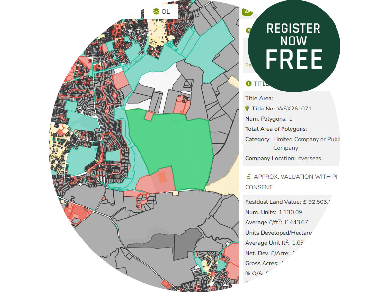

See the official Land Registry title plan your way
Landcycle offers a powerful tool which is a replica of the official Land Registry title plan map.
The map shows the registered title boundary for each of the registered properties in England and Wales. Properties are owned by different entities, for example charities, housing associations, companies or private individuals. Landcycle colour codes the land registry title plan map according to the ownership type.
Landcycle has also created integrated features within the mapped title. So by clicking on a title plot, we show the address, title number, size of the plot and any planning related constraints. We also show local values and If we have the information available specific property values both past and present.
The land registry map can be searched to show title size and value or ownership. So you can select for example, the map to show plots over a certain size and value and ownership type.
We also present the land registry map in different mapping styles which also include integration with ordinance survey (OS) and open street maps, so you can layer OS on top of land registry map to see if there are any discrepancies.
The following Layers are available in the Landcycle Map Hub
£/SqFt Values Layers:
- £199/sqft and Below
- £200-£249/sqft
- £250-299sqft
- £300-£350/sqft
- £351-£400/sqft
- £401-£450/sqft
- £451-£500/sqft
- £501-£550/sqft
- £551-£600/sqft
- £601-£700/sqft
- £701-£800/sqft
- £801 and Above
- PostalArea
- test3.zip
Agricultural Layers:
- Grade 1 Agricultural Land
- Grade 2 Agricultural Land
Ecology Layers:
- Ashdown Forest 400m
- Ashdown Forest 7km
- Ashridge Commons and Woods 12.6km
- Ashridge Commons and Woods 400m
- Biosphere Reserves
- Blanket Bog
- Calaminarian Grassland
- Chalk Rivers
- Coastal and Flood Plain Grazing Marsh
- Coastal Saltmarsh
- Coastal Sand Dunes
- Coastal Vegetated Shingle
- Deciduous Woodland
- Dorset Heathlands 400m
- Dorset Heathlands 5km
- Epping Forest 400m
- Epping Forest 6.2km
- Fragmented Heath
- Good Quality Semi-Improved Grassland
- Grass Moorland
- Limestone Pavement
- Local Nature Reserves
- Lowland Calcareous Grassland
- Lowland Dry Acid Grassland
- Lowland Fens
- Lowland Heathland
- Lowland Meadows
- Lowland Raised Bog
- Maritime Cliffs and Slopes
- Mountain Heaths and Willow Scrub
- Mudflats
- National Nature Reserves
- Nitrates
- Nitrates and Phosphates
- No main Habitat but additional habitat present
- Phosphates
- Purple Moor Grass and Rush Pasture
- Reedbeds
- Saline Lagoons
- Sites of Special Scientific Interest
- Special Areas of Conservation
- Special Protection Areas
- Thames Basin Heaths 400m
- Thames Basin Heaths 5km
- Thames Basin Heaths 7km
- Traditional Orchards
- Upland Calcareous Grassland
- Upland Flushes, Fens and Swamps
- Upland Hay Meadows
- Upland Heathland
Health and Care Layers:
- Hospitals
- Nursing Homes
- ProjPop (2022-32) 0-5%
- ProjPop (2022-32) 12- 20%+
- ProjPop (2022-32) -5 -0%
- ProjPop (2022-32) 5-8%
- ProjPop (2022-32) 8-12%
Infrastructure Layers:
- 1 Michelin Star
- 2 Michelin Stars
- 3 Michelin Stars
- Central Offices
- CIL Adopted
- CIL Draft Published for Consultation
- CIL Examination Report Published
- CIL Preliminary Draft Published
- CIL Report Submitted for Examination
- Data Centres
- Michelin Bib Gourmand
- Michelin Selected Restaurants
- New Towns
- New Towns March 2026
- No CIL
- Possible Subsidence Risk (2030 Projection)
- Possible Subsidence Risk (2070 Projection)
- Probable Subsidence Risk (2030 Projection)
- Probable Subsidence Risk (2070 Projection)
- Telephone Exchanges
Listing & Historical Layers:
- Conservation Areas
- Listed Buildings
- Registered Battlefields
- Registered Parks and Gardens
- Scheduled Monuments
- World Heritage Sites
Planning Constraint Layers:
- 5 Year Supply (0-2 Years)
- 5 Year Supply (2-3 Years)
- 5 Year Supply (3-4 Years)
- 5 Year Supply (4-5 Years)
- 5 Year Supply (5-6 Years)
- 5 Year Supply (6+ Years)
- Ancient Woodland
- Ancient woodlands Nov2025
- Built Up Areas 2024
- Emergency Planning Zones
- Flood Zone 2
- Flood Zone 3
- Green Belt 2021-22
- Green Belt 2023-24
- Historic Landfill Sites
- Local Landscape Designations
- National Forest Inventory
- National Landscape (AONB)
- National Parks
- OS Green Space
- Registered Common Land
- Settlement Boundaries
- Surrey Hills AONB Extension 2024 (Proposed)
Political Layers:
- GE24 Con Hold
- GE24 Green
- GE24 Independent
- GE24 Lab Gain
- GE24 Lab Hold
- GE24 LibDem Gain
- GE24 LidDem Hold
- GE24 PlaidCymru
- GE24 Reform Gain
- GE24 SNP
- LA Boundaries May 2024
- LA Con Coalition 2024
- LA Con Majority 2024
- LA Con Minority 2024
- LA Green Coalition 2024
- LA Green Majority 2024
- LA Green Minority 2024
- LA Ind Coalition 2024
- LA Ind Majority 2024
- LA Ind Minority 2024
- LA Lab Coalition 2024
- LA Lab Majority 2024
- LA Lab Minority 2024
- LA Lib Coalition 2024
- LA Lib Majority 2024
- LA Lib Minority 2024
- Local Authorities May 2021
- Parish
Power Gas & Drainage Layers:
- All Elec OHL
- Battery Operational 0-5 MW
- Battery Operational 20.1-100 + MW
- Battery Operational 5.1_20 MW
- Coastal Management- Advance the line
- Coastal Management- Floodable
- Coastal Management- Hold the line
- Coastal Management- No Active Intervention
- Coastal Management-Managed Realignment
- Distribution Network Operators
- Masts
- Nat Grid Elec OHL 400kv
- Nat Grid Elec Substations
- Nat Grid Gas Pipe
- Nuclear Power Stations
- Onshore Wind Operational 0-5 MW
- Onshore Wind Operational 20.1-100+ MW
- Onshore Wind Operational 5.1-20 MW
- Petroleum Sites
- Petroleum Wells
- PipeLine Features
- Pipelines
- Power Compensators
- Power Generators
- Power Substations
- Power Switches
- Power Towers
- Power Transformer
- Pumping Stations
- Radon Risk >30% HIGH
- Radon Risk 0-1% LOW
- Radon Risk 10-30%
- Radon Risk 1-3%
- Radon Risk 3-5%
- Radon Risk 5-10%
- River Basin Districts
- Solar Operational 0-5 MW
- Solar Operational 20.1-100+MW
- Solar Operational 5.1-20 MW
- Surface Water Management Catchments
- Telecom Cables
- Waste Water Plants
- Water Reservoirs
- Water Towers
- Water Treatment Plants
- Water wells
Retail Layers:
- Aldi
- Amazon Fresh
- Asda
- Booths
- Costco
- Dunnes Stores
- Farm Foods
- Heron
- Iceland
- Large Food Store
- Lidl
- Makro
- Medium Food Store
- Planet Organic
- Sainsburys
- Small Food Store
- Spar
- Tesco
- Very Large Food Store
- Waitrose
- Wholefoods
Schools Layers:
- Further Education
- Futher, Higher or University Education
- Higher or University Education
- Primary & Secondary Education
- Primary Education
- Primary, Secondary & Further Education
- Secondary & Further Education
- Secondary Education
Travel Infrastructure Layers:
- A Roads
- Airfield
- Airport
- B Roads
- Bridleways
- Byways
- Footpaths
- Minor Road
- Motorway Junction
- Motorways
- National Cycle Network
- Port or Docks
- Rail Feasibility Studies
- Rail Schemes Going Ahead
- Rail Schemes Under Consideration
- Rail Stations
- Rail Stations 1600m
- Rail Stations 800m
- Rail Track
- Restricted Byways
- Road Schemes Going Ahead
- Road Schemes Under Consideration
Get started in 30 seconds
Landcycle is free to access. No card details required to register
 Consent Preferences